Koya-san

posted in: +++, Class 3, Mountains, Temples, Woods | 0
Danjogaran
Danjogaran

If all the temples and shrines in Kyoto are too much for you, here is a smaller version up in the mountains south of Osaka. There are good mountain views both on the train and once you get there.

Take the JR to Umeda (or your favourite alternative!). From there take the Midosuji line to Namba. Change to the Nankai-Koya line to the last stop. At the ticket machine for the Nankai-Koya line there is a button for the Koya-san which gives you a ticket for both the train and the cable car up the mountain. The trip from Kobe is about 2 hours.

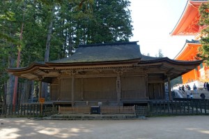
Once you get to the last stop the cable care is right there at the end of the platform. At the top there are buses, but the walk is a good one. You can go right or left. If you go right, the walk is along a “highway” with some good views of the valley below. A fairly long walk until you reach the gate to the “town”. I am not sure where the buses go. Once you get to the centre there are many temples to visit. Probably the most interesting place is the ancient cemetery with gigantic cedar trees; a very interesting place.

Class 3
+++

photo by 663highland

Takeda Castle

posted in: ++++, Castles, Class 4, Shrines, Temples, Woods | 0
Takeda Castle
Takeda Castle

Probably my favourite place (at least for now). A place the tourists haven’t found yet. A great place to bring a bottle of wine, a little cheese, and anything else. In winter be ready for snow. There isn’t much there, just the remains of a castle, extensive series of walls, and a wonderful view of the valleys below.

Take the JR to Himeji and change for the Bantan Line going to Todayama. Get off at Takeda (don’t take the express!). From the station you can see the castle walls on the hill across the tracks. There are some stores in the town straight ahead as you leave the station, if you want some food. There are two ways to get to the castle, the woods route and the road route. The woods route: across the tracks there is a shrine (long red steps) and a temple (white wall). Keep the shrine on your right and go along the white wall up the hill. This path will lead through a cedar grove and wind its way up to the castle. The road route: walk straight from the station, make the first right and walk through town. After about ten minutes make a right turn across the tracks and follow the road up the hill to the castle.

George liked to joke that these were the ruins of the car port.

Editor’s note: I think George would be both disappointed and amused to know that the tourists have indeed finally discovered this place and it’s now referred to in guide books as the “Machu Picchu of Japan.” It’s heavily promoted by local tourism boards, and now features an extensive system of paths covered with some type of synthetic material and lined with ropes. Kind of a drag since you used to be able to roam freely and have a picnic on the grass. We went on a rainy day and it wasn’t too busy, but it sees a lot of visitors these days.

New rope-lined paths
Model of Takeda at its Height in a Nearby Train Station
Model of Takeda in its former glory in a nearby train station
The paths and signs really detract from the overall atmosphere, but it's still definitely worth a visit!
The paths and signs really detract from the overall atmosphere, but it’s still definitely worth a visit!
Wrap-around Train Promotion for Takeda

Lake Chuzenji

Mt. Nantai & Lake Chuzenji


While you are at Nikko keep on going. A short bus ride up a very winding road is the town of Chuzenjiko Onsen. A real Japanese tourist spot in season. If you go there out of season it is empty, so stay away from Japanese holidays. This is a really beautiful spot for nature lovers. Lakes, riverse, waterfalls, lots of trails in the woods. Most hotels will have hot spring baths.

From Nikko, take a bus going to Chuzenji or to Yumoto Spa. Get off at Chuzenjiko Onsen. Right there will be Kegon Falls and a rope way to a good view of the mountains and lake. The falls are wonderful. From the bus stop you can go right or left around the lake. If you go left you will pass hotels and restaurants and eventually come to a shrine. Keep following the shore of the lake and pass summer houses of various countries. If you go to the right you will pass hotels and restaurants but once out of town you can walk forever. Pick up the “Salamander Trail” (I actually saw one!). This will take you right along the shore of the lake until you come to a ferry boat landing. From there follow the highway and on the right you will come to another waterfall. Follow the river upstream along a very delightful trail. You will come to an area that opens up into a mountain meadow. Beautiful views of the surrounding mountains. Flowers everywhere, in season. Eventually there will be another waterfall with some shops at the base. Walk up the right side of the waterfall and you will come to another lake. Stay to the right and you will come to Yumoto, just a collection of hot spring hotels. Look for the temple and you will find a swamp with hot springs. This is a long walk but very easy going. Give yourself about five hours, including many stops to eat and take photos. Then take the bus back to Chuzenji or Nikko.

Class 3
++++

photo by Uraomote Yamaneko

Lake Biwa (west side)

Lake Biwa at Sunset
Lake Biwa at Sunset

This is good for some serious hiking or beach sitting. Or spend two days and do both. It is very easy to get to. Take the JR to Omi-Miako. There is one train a day that leaves from Sannomiya and goes directly there about 9.30 am. That’s the quickest way. If you miss that, change at Kyoto for the train to Omi-Miako. At Omi-Miako the beach is one way the mountains are the other. The beach is very long and you can pick your spot depending on the amount of company you want. For the mountains just walk through the rice fields (there is a road) to a very busy highway. At the highway turn left and you will come to a river (there may not be any water). At the river turn right and walk uphill.

This can be a long walk and there is a bus that runs about every hour. It is about an hour’s walk with only one turn; when you come to a house with some vending machines, turn right. This will bring you to a ski-lift. The ski-lift takes you to a rope way, which takes you to the end of the the rope way. There you will find all kinds of trails leading in many different directions. This is not easy walking but it is deep woods, cold streams, a few monkeys and places to camp. At the top of the rope way there is a limited restaurant to the right. There is no map at the top, but trails are well marked in kanji. It would be best to have some kind of map before you start walking. There are probably other ways down but the rope way, ski-lift, and bus is probably the simplest and most relaxing. You can walk for as long as you like on top.

Class 4
+++

photo by A giau